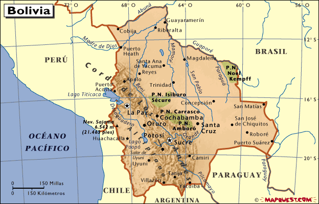
This route begins in the town of Oruro, known as "The Bolivian Folklore Capital" because of the Lavish Folklore Carnival held there every year in honour of the Virgin of Socavón, which is considered to be the utmost expression of Bolivia's popular and traditional cultures.
The weather in Oruro can be very cold in winter. Situated at al altitude of 3,706 m.a.s.l., the characteristic landscape on the Oruro - Machacamarca route is a bleak mountain plateau with a view of the Three Crosses mountain range in the Central and Lacustrian watercourses of the Amazon and La Plata. The highest peaks in this mountain range are Negro Pabellon (5,400 m), Toro peak (5,180 m) and Azanaques (5,150 m).
Access
Access to this route is from the town of Oruro by bus. Buses leave the main bus terminal in the town every day.
There is also a daily overland transport service from the town of Oruro.
Sepulturas
Originally a mining settlement, this is one of the towns that formed part of the industrial satellites of the Colonial mining town, to which minerals were taken on beasts of burden for processing. These ore processing centres were one of the most original features of American towns. Churches that date back to 1785 are also worth a visit.
Uru Uru Lake
Situated in the provinces of Machacamarca, this lake is 21 k. long, 16 k. wide and 1 m. deep, formed by the overflow of the Desaguadero river. Typical fauna of the region can be observed in this area and there are fish in the lake, such as a local species of mackerel.
Cala Cala
An Aymara place name which means region of many rocks, situated in the Cercado province, 21 k. from the town of Oruro. The area in which cave paintings can be found is also known as "Quellcata", which means written. Camelidae paintings are clearly predominant, in different tones of red, white and black.
Machacamarca
A small village considered to be the main destination for railway machinery, located about 30 k. from the town of Oruro. The abundant willow trees add to the picturesque image of a quaint town, with old chalets that were once the homes of railway engineers at the end of the last century. Thermal baths with medicinal properties are located nearby. A mining plant of the same name is located 3 k. away from this village.
Poopo
This area has all the characteristics of a mining centre, with interesting sites like the XVII century church in the old town, now totally abandoned, situated at the edge of the river facing the new town that has developed around the old ore smelting towers that rise up on the side of the road, their chimneys no longer burning.
Urmiri
Situated 68 k. From Pazña, Urmiri is considered to be one of the most important resorts on this route. It also has a colonial church that dates back to the XVII century.
Challapata
A settlement situated 38 k. from Pazña at the crossing of the Oruro - Potosi road, this is one of the most important areas on Oruro's commercial route. Its urban structure starts in the old town, where there is a prominent religious complex. From the higher part one can see the enchanting colonial images and highland plateau scenery in all its splendour.
|

![]() World
News World
Top Stories Web
Search Web
Images
Search Web
Groups Search Web
Catalogs Web
Directory
News Search
World
News World
Top Stories Web
Search Web
Images
Search Web
Groups Search Web
Catalogs Web
Directory
News Search


